A strong El Niño is raising Pacific Ocean temperatures, affecting everything from the fish we eat to how diseases spread.
Even before Hurricane Patricia lashed into Mexico this weekend, the central Pacific Ocean had already been flogged by a record number of tropical storms. Give some credit to El Niño.
As this year’s strong El Niño raises ocean temperatures in the central and eastern Pacific, it appears to be following a classic pattern of acting both as a match that helps ignite tropical storms and as gasoline that makes them grow stronger.
El Niño is one phase in a years-long back-and-forth in Pacific Ocean temperatures and winds near the equator. Low-altitude trade winds that typically blow to the west weaken or reverse course during an El Niño.
And warm water that would usually shift toward Asia instead builds up in the eastern and central Pacific. When a tropical thunderstorm hits, the unusually warm water can set off a cascading series of events that generates and sustains the swirling vortex of a full-blown hurricane.
Changes in Pacific wind patterns tied to El Niño—particularly the weakening of winds blowing from the west high in the atmosphere—also set the stage for bigger storms by reducing wind shear, says Phil Klotzbach, a Colorado State University atmospheric scientist who studies tropical storms. Wind shear occurs when air currents at a lower altitude blow in a different direction from winds higher in the atmosphere, which can destabilize and weaken a hurricane.
In the case of Patricia, water temperatures and winds conspired to produce the most powerful hurricane ever recorded in the Western Hemisphere, with winds reaching 200 miles per hour. The storm lost power shortly after making landfall, and was downgraded to a tropical depression on Saturday.(Read: “Why Hurricane Patricia’s Name May Be Retired.”)
Record Number of Storms
It’s hard to say if El Niño deserves credit for Patricia. It’s a little unusual for El Niño-fueled storms to emerge that far east, because the wind patterns are different there, Klotzbach says. If it made any contribution, it was probably with warmer water.
But Klotzbach is confident it has a hand in the unusual number of storms whipping across broad expanses of the central Pacific this year.
This year has seen eight tropical storms big enough to earn names, double the previous record. On a scale scientists use to add up the energy in storms, this season has also been a whopper, at more than six times higher than usual. But most storms attract little notice, because the action happens far from land. “Hawaii’s had some close calls this year,” Klotzbach said. “But fortunately no hits.”
There’s an upside in the Atlantic, where this hurricane season producedroughly a third of the usual tropical storm activity, according to the National Weather Service’s National Hurricane Center. El Niño years translate into fewer tropical hurricanes there because it strengthens upper-level winds blowing from the west that produce stronger wind shear, tearing apart potential storms.
The Pacific hurricane surplus is just one of the many effects El Niño can have around the globe. While this particular El Niño isn’t expected to peak until late fall or early winter, and could persist until spring in the Northern Hemisphere, scientists say past history, combined with the current intensity, make a number of scenarios likely:
- Flooding and landslides in the Americas.A massiverecent mudslidenorth of Los Angeles that swept away one man and trapped nearly 200 vehicles on a highway might have been a taste of things to come. El Niño wind patterns push tropical moisture towards the Americas, which can translate into heavy rains, flooding and landslides in places like California and Peru. The El Niño of 1997 and 1998 caused an estimated $2 billion in property damage in Peru, according to the World Bank.
The historic California drought could make matters worse. A downpour could trigger flash floods if rain falls on ground baked so hard it can’t readily absorb the water, said Lisa Goddard, director of Columbia University’s International Research Institute for Climate and Society, and a climate scientist whose work focuses on El Niño. “The fact that it’s coming on top of this multi-year drought—yeah, it’s going to be bad,” she said
- Drought in southeast Asia and Australia.Parts of the west Pacific could be left wishing for some of that California rain. In Australia, past El Niño years have cut winter and spring precipitation by more than a quarter, chiefly in the north and east, according to theAustralian Bureau of Meteorology. Last month was the third driest September on record, and the remainder of the year is expected to be warmer and drier than normal, a trend blamed partly on El Niño.
The lack of rains is also evident in wildfires choking the air in Indonesia. Monsoon rains usually extinguish the fires, but during the El Niño of 1997 and 1998, dry weather kept fires burning for months into the wet season. Now, officials are warning that could happen again this year.
- Scrambled fisheries.Off the coast of Peru, the tiny anchoveta, a 14-centimeter-long type of anchovy, is one of the world’s biggest fisheries. But the warm El Niño can decimate populations of these fish, which feed on plankton that grows in cold, nutrient-rich coastal waters. This year, Peru has already closed the anchoveta fishery, over the objections of fishermen, said Francisco Chavez, a senior scientist at theMonterey Bay Aquarium Research Institute in California.
Meanwhile, warm waters off North America have lured trophy fish such as tuna and marlin to California, north of their usual haunts off the coast of Mexico. This was set in motion over the last two years, before El Niño kicked in, courtesy of an unusual increase in surface water temperatures in a huge patch of the Pacific, said Nate Mantua, an expert in climate and fisheries at the National Oceanic and Atmospheric Administration’s Southwest Fisheries Science Center, in Santa Cruz, Calif.
El Niño could amplify that trend. If it’s like past El Niño events, a deeper layer of warm water could push north up the coast, bringing with it species such as yellowtail and Bluefin tuna, meter-long Humboldt squid, and the opah, the world’s only known warm-blooded fish, Mantua said. But warmer oceans are bad news for West Coast salmon, at a time when many U.S. salmon runs are already on the Endangered Species list.
- Disease outbreaks.Natural disasters provide breeding grounds for a variety of diseases. El Niño-related flooding is associated with an uptick in cholera, dengue, and malaria in some parts of the world, while drought can lead to wildfires that produce respiratory problems, according toa study this year in the journal PLOS Current Outbreaks.
Despite the anxiety surrounding El Niño, the worldwide toll might be no different from other years. Eye-popping damage estimates are attributed to extreme El Niños, as much as $45 billion during the episode in 1997 and 1998.
But a 2005 study found that while destruction in some regions was higher, the total number of natural disasters reported around the world was similar to years with moderate ocean conditions in the Pacific. Goddard, the study’s lead author, says strong El Niño’s and their opposite—La Niñas—could have an up side. Because their effects have bcome well-known, people can prepare.
“We have disasters all the time,” Goddard says. “It’s du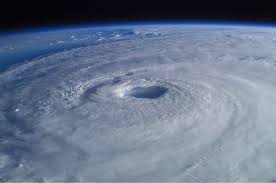 ring El Niño that those happen to be more focused in certain places and we can predict that.”